


Gas detection surveys
Drone gas leak surveys that detect methane and up to 10 gases in real time, mapping concentrations across large sites and at different heights.
Available Files: 2D & 3D Gas Maps, CSV Data & Reports
10
Gases Per Flight
CH₄
Methane Detection
Real
Time Leak Mapping
3D
Gas Maps
Aerial Gas Leak Detection Surveys
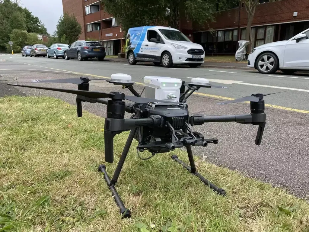
Drone Site Surveys offers aerial gas leak detection using drones. Our sensors monitor a range of gases in real time, including methane, so we can identify where gas is escaping and how it moves across your site, allowing repairs to be carried out safely.
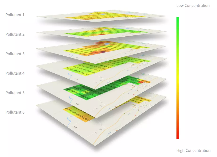
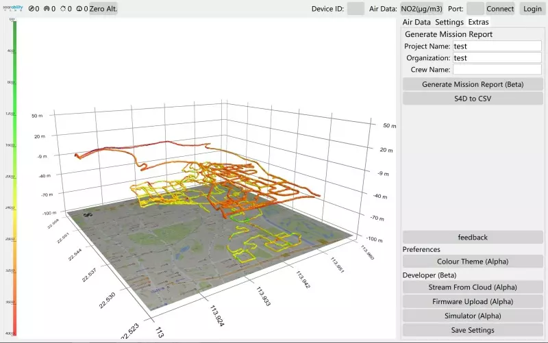
Flying a drone lets us scan large areas quickly and collect enough data for a full analysis of the site. Results are shown as 2D maps and 3D models, with concentration levels at different heights.
The data can be used for gas leak detection, emission monitoring and environmental reporting, with raw data supplied for your own analysis. For wider pollution mapping, including particulate matter, see our air quality surveys.
Example Image Quality
Click each image to view example image quality
What Your Gas Detection Survey Can Include
Choose the gases, area and outputs you need. Data can be collected by drone, vehicle or wearable sensor.
| Deliverable | What it is | Included |
|---|---|---|
| Multi-gas detection | Up to 10 gases measured in a single flight, including methane. | Standard |
| Methane leak detection | Real-time methane readings tied to position and height, to trace leaks to their source. | Standard |
| 2D and 3D gas maps | 2D grid, 2D contour and 3D point cloud maps showing concentration levels. | Standard |
| Raw CSV data | Full data set for analysis in Excel, R or MATLAB. | Standard |
| Vehicle-mounted survey | Sensors fitted to a vehicle with our own bracketry, for town centres and pipeline routes where flying is impractical. | Optional |
| Wearable sensors | Hands-free sensors for operatives approaching potentially hazardous sites. | Optional |
| Vapour sampling | Sample bags on the drone collect air or gas samples over target areas for laboratory analysis. | Optional |
The gases we measure depend on the sensor set-up for your survey. Tell us what you need to detect and we’ll confirm the right configuration.
At a Glance
Capture
Up to 10 gases
Capture method
Drone, vehicle or wearable
Pilot network
Nationwide
Physical sampling
Optional
Scaffold needed
None
Coverage
Mainland UK
Get a Quote
Send us an address. We will come back the same working day with a price and a scope.
Why Clients Choose Drone Gas Detection Surveys
Mapping gas from the air gives a fuller picture than handheld or fixed monitoring. Clients benefit from:
Knowing where gas is escaping lets you reduce risk, prioritise repairs and act on real evidence rather than assumptions.
The result?
A clear picture of gas levels across your whole site, showing where leaks are and where the gas is going.
Methane (CH₄)
Methane leak detection
Methane is flammable and can build up to dangerous concentrations in enclosed or low-lying spaces. It is also a powerful greenhouse gas, so small leaks that run unnoticed soon add up.
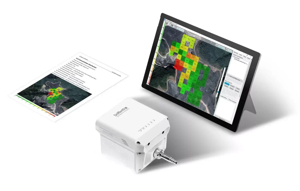
Our Sniffer4D payload maps methane in real time across oil and gas sites, pipelines, landfill and biogas plants, so leaks can be found and fixed early, with clear evidence for repairs and environmental reporting.
Leaks located, not guessed.
CAA
CAA Operational Authorisation 11363
Fully insured, with £10m public liability and specialist UAV cover
Why drones
Why use drones for gas detection?
Walking a site with a handheld gas detector is slow and only covers the routes you walk. A drone scans the whole area, including at height, in a single survey, and keeps people away from potential leaks.
- No one in harm’s way. Measure hazardous areas without sending people in.
- Whole-site coverage. Map gas levels across the entire area, not just along walked routes.
- 3D insight. See how gas concentrations change with height.
- Flexible capture. Drone, vehicle or wearable, depending on the site.
- Physical samples. Collect gas samples by drone when laboratory analysis is needed.
Gas concentrations mapped across the whole site, at different heights.
Who we work with
Gas detection surveys for energy, waste and industrial sites
We work with oil and gas operators, utilities, landfill and waste operators, industrial sites, local authorities and environmental consultants who need reliable data on gas leaks and emissions.
Our service is suitable for
- ›Oil and gas facilities
- ›Gas distribution pipelines
- ›Landfill sites
- ›Waste and recycling facilities
- ›Wastewater treatment works
- ›Biogas and anaerobic digestion plants
- ›Industrial and manufacturing sites
- ›Local authorities
- ›Environmental consultants
- ›Agriculture
For leak detection and repair programmes, we can repeat surveys on a schedule to confirm repairs and track emissions over time.
Why choose us
Why choose Drone Site Surveys?
Reliable gas data depends on how and where it is collected. Our CAA approved pilots fly a planned grid across your site with a Sniffer4D sensor payload, recording methane and other gases with their position in real time, at different heights as well as at ground level.
We turn the readings into clear 2D maps and 3D models that show where concentrations are highest and how the gas disperses. Initial results are often available on site straight after the flight. You get the evidence to find the leak, not just a single reading from a fixed monitor.
Clients choose us for gas detection surveys because we offer:




How it works
Our gas detection survey process
From first enquiry to secure delivery, every survey follows the same six steps, so you always know what happens next and when.
Tell us about the site
Tell us about the site and which gases you need to detect. We’ll recommend the right sensors and whether to capture by drone, vehicle or wearable.
Planning and quote
We carry out a desktop assessment of the property and the surrounding airspace, check the survey against current UK drone regulations, and prepare your quote. You receive it by email with no obligation, along with the airspace map for your site and an example delivery so you can see exactly what you’ll be getting.
Booking your date
Once you’re happy with the quote we add your job to the schedule and start monitoring the Met Office forecast. In the meantime we prepare the pre-flight paperwork, including our risk assessment and method statement (RAMS), which we can send over for your records. As soon as we have a clear weather window and pilot availability, we confirm your attendance date. You don’t normally need to be on site.
The survey
Our CAA approved pilots fly a planned grid across the site, recording gas levels and position in real time, with physical samples collected if required.
Processing
The readings are checked and turned into 2D grid, 2D contour and 3D point cloud maps, with the raw data supplied as a CSV file for Excel, R or MATLAB. Initial results can often be shown on site straight after the flight.
Delivery
We email you a link to our secure online portal, where your imagery, reports and any other agreed outputs are ready to view, download and share with your team or contractors. Alongside the deliverables you’ll find a folder containing the pre-flight paperwork, a copy of the drone airspace map for your site and any other relevant documents, so everything from the survey is in one place.
Request a Quote
Request a gas detection survey quote
Whether it’s a single landfill site, an industrial plant or a long pipeline route, we can tailor the survey to the gases and area you need to cover.
Send us the address and a brief description of what you need, and we will come back with clear pricing and deliverable options.
Prefer to Speak to Us?
If you’d rather speak to one of the team, that’s no problem. Simply call the number below and one of our team will be more than happy to help.
Get a Quote
The quote form is taking a while to load. Open the simple form, call 0345 017 5592 or email info@dronesitesurveys.co.uk.
In The Know
Frequently Asked
Questions
Answers to the questions we are asked most often about gas detection and methane surveys. If yours is not covered here, give us a call.
Which gases can a drone detect?
Up to 10 gases in one flight, depending on the sensors fitted. These include ozone, nitrogen dioxide, carbon monoxide, sulphur dioxide, hydrogen sulphide, carbon dioxide, ammonia, methane, hydrogen fluoride, oxygen and hydrogen.
Can a drone find methane leaks?
Yes. The Sniffer4D payload measures methane concentration in real time as the drone flies. The readings are mapped so you can see where levels peak and trace them back to the source.
What sites do you survey?
Oil and gas facilities, gas pipelines, landfill and waste sites, wastewater works, biogas plants, industrial sites and farms, as well as any site where a gas leak is suspected.
How is the data delivered?
As 2D grid, 2D contour and 3D point cloud maps, with the raw data supplied as a CSV file for Excel, R or MATLAB, all delivered through our secure online portal.
How do the results compare with exposure limits?
We deliver the data as clear, actionable information, so you can compare it against the workplace exposure limits in the HSE’s EH40/2005, used with the COSHH Regulations 2002.
Can you collect physical samples?
Yes. Sample bags attached to the drone can collect air or gas samples over target areas for laboratory analysis.