

Drone Roof Survey
A professional drone roof survey gives you a clear, detailed view of your roof condition without the cost, disruption and safety risks associated with scaffolding or unnecessary work at height.
Drone Site Surveys provides independent roof inspections for commercial buildings, residential properties and multi-site property portfolios across the UK.
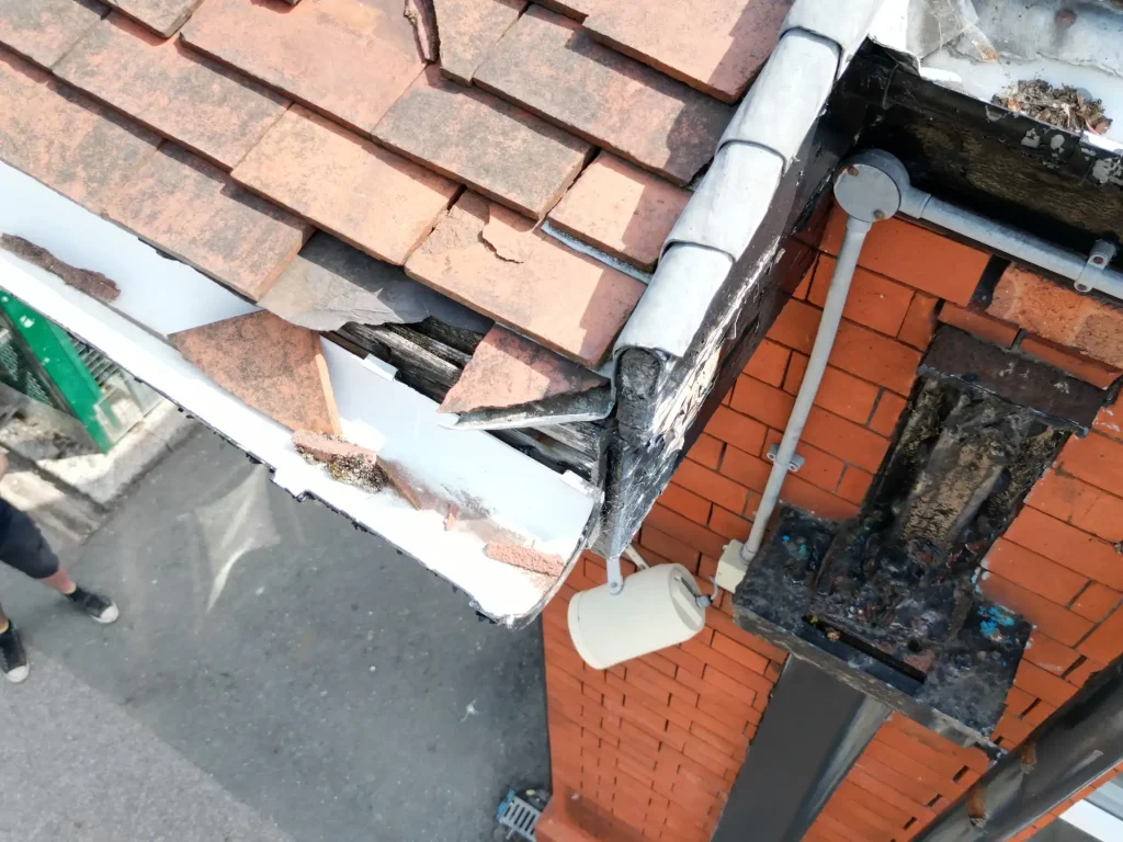
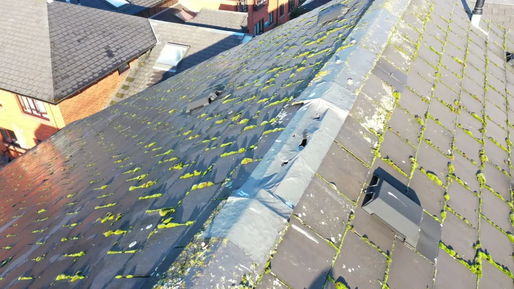
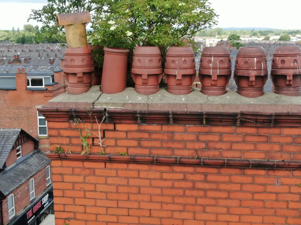
Using high-resolution drone imagery, we can inspect roof coverings, chimneys, rainwater goods, flashings, rooflights and other difficult-to-access areas in exceptional detail.
From high-resolution inspection imagery and video footage to Building Surveyor-led roof condition reports, accurate measurements, 3D and Revit modelling and technical drawings, we can tailor the survey and deliverables to suit your property, portfolio and project requirements.
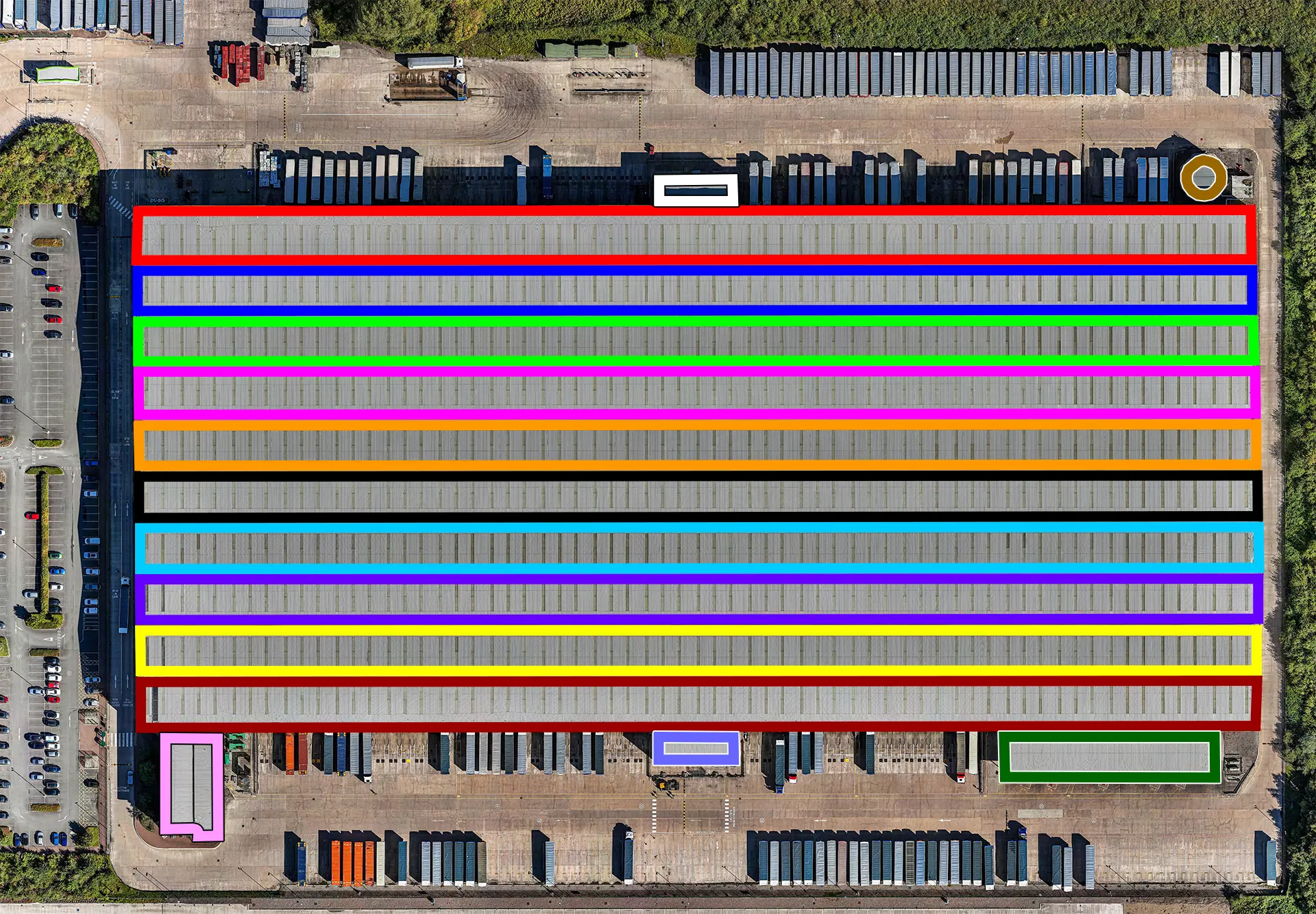
We section each roof into coloured folders for ease of fault location analysis.
Book Your Drone Roof Survey Today
Why get a Drone Roof Survey?
A roof can develop problems long before they are visible from ground level. Damaged tiles, deteriorated flashings, blocked gutters, defective roof coverings and other issues can be difficult to assess safely without gaining access to the roof.
A drone roof survey gives you a detailed visual record of the roof from above and from angles that would normally be difficult to reach.
Depending on the roof type, an inspection can help identify visible issues such as:
- Missing, cracked or slipped tiles and slates
- Damaged roof coverings
- Water ingress points
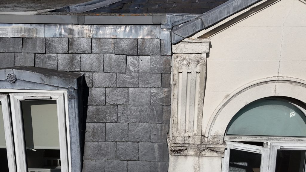
- Defective flashings and leadwork
- Blocked gutters and drainage outlets
- Standing water on flat roofs
- Damaged rooflights
- Corrosion and failed fixings
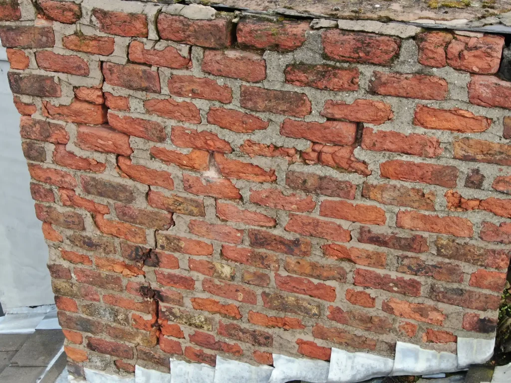
- Cracking around parapets and junctions
- Storm or impact damage
- Areas that may need further investigation
The result is clear photographic evidence that can support maintenance decisions, professional assessment, repair planning and prioritisation.
Roof surveys for insurance claims
Insurers and loss adjusters normally want evidence of damage before a claim can progress. A drone survey produces dated, high-resolution photographs of the affected areas without anyone needing to access the roof, which can be used to support a claim, show the extent of storm or impact damage, and record the condition of the roof before any repair work starts. Where a previous survey exists, earlier imagery can also be compared against the current condition, which helps separate sudden damage from longer-term wear.
All flights are carried out by CAA-registered pilots. We hold £10m public liability insurance and specialist UAV cover meeting the requirements of EC Regulation 785/2004. Copies of our insurance certificate, operations manual and site-specific risk assessment and method statement (RAMS) are provided before we attend site, as managing agents, facilities teams and principal contractors usually need these for their own records.
Request Your Drone Roof Survey Quote
A Safer and More Efficient Way to Assess Roof Condition
Traditional roof inspections can require scaffolding, access towers or MEWPS (mobile elevated work platforms) before the roof can be properly viewed.
Using a drone allows us to inspect roofs without putting people to work unnecessarily at height. It can also reduce disruption around the building and provide access to areas that may be difficult to inspect using traditional methods.
Our pilots capture both wider overview images and detailed close-ups, helping you understand the overall roof condition while also focusing on specific areas of concern.
For larger buildings, this can be particularly useful when a substantial roof area needs to be inspected efficiently.
What Your Roof Condition Survey Includes
Every survey is planned around the property and the information you need.
Depending on the agreed scope, your survey can include:
High-Resolution Roof Imagery: Clear overview and close-up photographs covering individual sections of the roof.
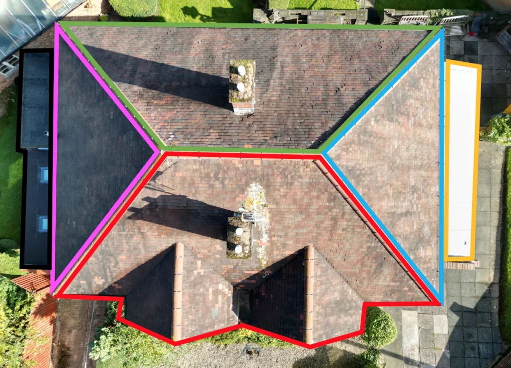
Organised Inspection Images: Images are separated into clearly defined roof areas or elevations into coloured folders, making it easier to identify where each photograph was taken.
Building Surveyor Report: Where required as an optional extra, captured imagery can be reviewed by our experienced Building Surveyors, with a written RAG (Red, Amber, Green) condition report which will identify visible defects, their relative severity and any areas requiring further attention.
Measurements and 3D Data: Using photogrammetry or LiDAR, we can create accurate 3D and Revit models for reliable roof measurements, BIM workflows, AutoCAD .dwg drawings and other technical outputs.
Secure Digital Delivery: All agreed survey imagery, reports and supporting information are delivered through our secure online portal, giving authorised teams and stakeholders easy access to view, share and download project information as required.
Choose a Safer, Faster Surveying Method
Commercial, Residential & Portfolio Roof Inspections
We carry out roof inspections across a wide range of property types, from individual homes through to large commercial buildings and nationwide property portfolios.
Our service is suitable for:
- Offices and commercial premises
- Warehouses, factories and industrial buildings
- Retail units, shopping centres and retail parks
- Residential apartment blocks and housing developments
- Housing association and social housing properties
- Schools, colleges, universities and education estates
- Hospitals, clinics and other healthcare buildings
- Local authority and public-sector buildings
- Historic, heritage and listed buildings
- Hotels, leisure centres and hospitality properties
- Care homes and assisted-living facilities
- Distribution centres and logistics hubs
- Churches and places of worship
- Agricultural and rural buildings
- MOD, defence and secure estate buildings
- Prisons and custodial facilities
- Construction sites and newly completed developments
- Multi-site commercial and residential property portfolios
For clients managing multiple properties, we use a consistent capture and reporting approach across every site, helping teams compare condition and prioritise maintenance.
Why Choose Drone Site Surveys?
Drone Site Surveys specialises in professional survey and inspection data capture rather than general aerial photography.
Our pilots work specifically across commercial and domestic properties, as well as building, construction and land surveying environments. With experience in roof and façade inspections, they understand how to capture clear, relevant imagery that supports practical condition assessment, defect identification and informed decision-making.
Clients choose Drone Site Surveys for our specialist experience, professional standards and independent approach:
- CAA-authorised drone operations
- Experienced survey and inspection pilots
- £10 million insurance cover
- All necessary pre-flight permissions identified and secured
- Independent roof and property inspections
- Building surveyor reporting available where required
- Nationwide UK coverage
- Secure online delivery of survey data and imagery
- Optional thermal imaging, measurements and 3D modelling
We do not carry out roofing repairs or remedial works. This means our focus remains on providing clear, impartial information about the condition of your property, helping you make informed decisions without any pressure to purchase repair services.

Get a Clear View of Your Roof Condition Today
Our Drone Roof Survey Process
1. Tell us about the property
Email us the site address with postcode and what you need from the survey. We’ll come back with the options available.
2. Planning and quote
We carry out a desktop assessment of the property and the surrounding airspace, check the survey against current UK drone regulations, and prepare your quote. You receive it by email with no obligation, along with the airspace map for your site and an example delivery so you can see exactly what you’ll be getting.
3. Booking your date
Once you’re happy with the quote we add your job to the schedule and start monitoring the Met Office forecast. In the meantime we prepare the pre-flight paperwork, including our risk assessment and method statement (RAMS), which we can send over for your records. As soon as we have a clear weather window and pilot availability, we confirm your attendance date. You don’t normally need to be on site.
4. The survey
Our CAA approved pilot works systematically around the building, capturing the agreed roof areas in high-resolution overlapping imagery.
5. Processing
Every image is checked and organised into colour-coded folders by roof section. Any reporting, measurements or additional outputs you’ve asked for are completed at this stage.
6. Delivery
We email you a link to our secure online portal, where your imagery, reports and any other agreed outputs are ready to view, download and share with your team or contractors. Alongside the deliverables you’ll find a folder containing the pre-flight paperwork, a copy of the drone airspace map for your site and any other relevant documents, so everything from the survey is in one place.
Request an Independent Drone Roof Survey Quote
Whether you need to investigate a specific roof issue, understand the overall condition of a property or assess multiple buildings across a portfolio, we can tailor our survey to your requirements.
Send us the property address, or a list of properties for larger portfolios, along with a brief description of what you need. We will review the site and recommend the most appropriate drone roof survey service, with clear pricing and deliverable options based on the level of detail and output required.
FAQ's
What is a drone roof survey?
A drone roof survey is a visual inspection of a roof carried out using a remotely piloted aircraft instead of scaffolding, a cherry picker or roof access. High-resolution images are captured from above and from angles that are difficult to reach on foot, producing a dated photographic record of the roof’s condition that can be reviewed, shared and stored.
How much does a drone roof survey cost?
Cost depends on the size and complexity of the building, its location, and whether you need imagery alone or a fuller package. As a guide, for condition imagery alone, a single domestic property starts at £250.00+VAT or a small commercial roof starts at £350.00+VAT, with multi-site portfolios priced per building. Because there is no scaffolding or access equipment to hire, a drone survey is typically a fraction of the cost of a traditional inspection. If you have multiple properties to survey, depending on location our price can come down considerably.
How long does a drone roof survey take?
Most single domestic building surveys take can under an hour on site. Larger or more complex buildings take longer, and multi-site portfolios are usually scheduled across consecutive days to reduce travel costs. Imagery is normally delivered within 48 hours from completion, with written condition reports and modelling following shortly after. It should be noted that planning, processing and travelling to site take a lot longer than the time spent onsite.
Can a drone roof survey be used for an insurance claim?
Yes. Insurers and loss adjusters generally want photographic evidence before a claim can progress, and drone imagery provides dated, high-resolution detail of the damage without anyone accessing the roof. We can supply the raw imagery, a written condition report, or both, depending on what your insurer requires. Where an earlier survey exists, comparison imagery can help demonstrate that damage was sudden rather than long-term wear.
Are you insured to fly over buildings and occupied sites?
Yes. We hold £10m public liability insurance and specialist UAV cover meeting the requirements of EC Regulation 785/2004. Copies of our insurance certificate, operations manual and a site-specific risk assessment and method statement (RAMS) are provided before we attend site, as managing agents, facilities teams and principal contractors normally need these for their own records.
Can a drone survey detect leaks and water ingress?
A standard survey identifies the visible defects that commonly cause water ingress, such as slipped tiles, failed flashings, split felt and blocked outlets. Where the source is not visible, a thermal examination can be added, this is especially good technology suitable for flat roofexaminations: thermal imagery highlights temperature differences caused by trapped moisture, which often reveals the path of a leak that standard photography cannot show.
Can you survey flat roofs, fragile roofs and asbestos cement sheeting?
Yes, and these are among the strongest cases for a drone survey. Fragile coverings such as profiled cement sheet and older rooflights will not reliably bear a person’s weight, so inspecting them remotely removes the risk entirely. On flat roofs, aerial imagery also shows ponding, debris and failed detailing that are difficult to judge from the roof surface itself.
Can you fly in rain or high winds?
No. Surveys are carried out in dry conditions with wind speeds within our operating limits, as rain on the lens and unstable conditions compromise image quality and safe flight. We monitor forecasts ahead of every booking and will rearrange rather than fly in marginal weather. Rescheduling for weather is free of charge.
Do I need to be on site during the survey?
Not usually. We need access to the ground around the building and a point of contact for site access, but no one needs to accompany the pilot. For occupied or public-facing sites we agree a time and any cordoning requirements in advance so the survey causes as little disruption as possible.
Is a drone survey as good as a physical roof inspection?
For assessing visible condition, a drone survey often shows more than a physical inspection, because it covers the whole roof from angles that cannot safely be reached on foot. It is a visual inspection and photographic record rather than an intrusive or structural investigation, so where a defect needs opening up or testing, the imagery identifies exactly where that work should be targeted.
What do I receive after the survey?
As standard, a set of high-resolution images covering the full roof area. If required, you can then add a written condition report, thermal examination, measured drawings, or 3D and Revit models built from the same survey data – one visit, as much or as little detail as you need, as long as this agreed in advance.
Do you cover my area?
We survey nationwide across mainland UK. Travel is included in all of our fixed quotations, and multi-site portfolios are routed to keep costs down.