
When you are making decisions worth millions, “good enough” data is never enough. Drone Site Surveys provides land developers with high-resolution aerial images and accurate data transformed into decision-ready outputs you can measure, share and trust.
Using the latest drone technology and advanced photogrammetry, we create a detailed 3D model of your site, complete with tools to measure distance, area, volume and angles. All outputs are georeferenced and delivered through our secure online platform, providing you and your team with instant access without the need for specialised software.
Why Land Developers Choose Drone Site Surveys
- Clarity from Day One: View the entire site in context rather than isolated snapshots.
- Decisions Backed by Data: Quantify cut and fill, verify design intent and track progress over time.
- Speed and Safety: Rapid data capture with minimal disruption and fewer boots on the ground in hazardous areas.
- Seamless Integration: CAD and GIS-friendly deliverables that fit directly into your workflow.
- Compliance Covered: Full documentation, including RAMS, keeps your project compliant with UK regulations.
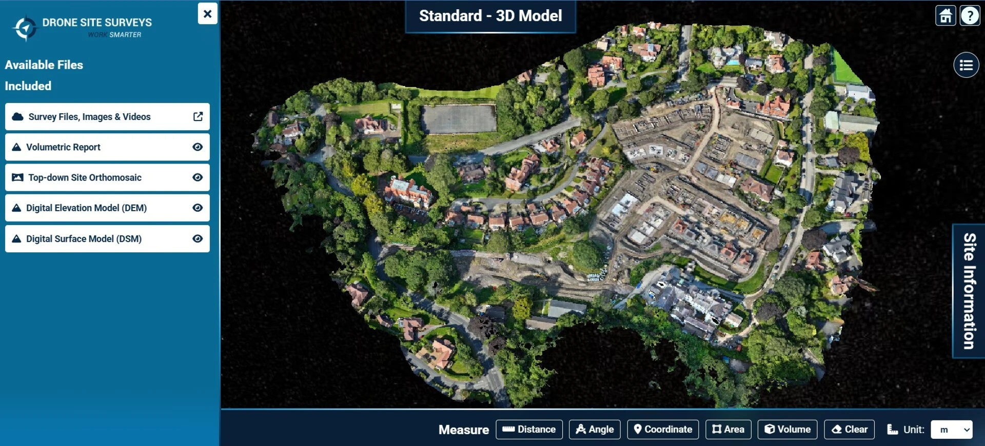
Rich 3D Models with Real Measurement Tools
Your interactive 3D model is more than just a visual aid. It is a working dataset designed to provide accurate, actionable information:
- Distances and Angles: Check road alignments, setback lines and façade angles instantly.
- Areas: Calculate plot sizes, roof coverage and hardstanding zones for planning and valuations.
- Volumes: Accurately measure cut and fill, stockpile volumes and material movements.
- Profiles and Sections: Take cross-sections anywhere on-site to understand gradients and elevation changes.
Because the model is georeferenced, your measurements remain consistent across the entire development.
Geolocation That Fits Your Workflow
Accuracy is our priority from the outset:
- Ground Control Points (GCPs): On-site targets tied to known coordinates achieve sub-10mm accuracy in most cases.
- .KML Files: Import site boundaries, phases and layouts directly into Google Earth or GIS software.
- Coordinate Systems: Data is delivered to your specified grid and datum to keep CAD and GIS teams aligned.
Secure Online Delivery Portal with White Labelling
All deliverables are provided through our secure online portal, designed for speed, simplicity and collaboration. This portal can also be white labelled with your company branding, ideal for sharing results with clients, stakeholders and contractors.
Log in, view and download your data, models and reports in one place. Shareable links make distributing information fast and secure.
What You Receive in Your Delivery Pack
We provide everything required for complete integration into your workflow:
– All source images used to create your 3D model
– High-resolution orthomosaic created from hundreds of aerial images
– Interactive 3D model with built-in measurement tools, viewable online
– .DWG site overview for seamless CAD integration
– Full volumetric report with clear calculations and methodology
– Geospatial files, including GCP data and .KML files for GIS workflows
– RAMS and compliance documentation to meet UK safety regulations.
Turnaround Times and Pricing
For most land development projects, we deliver results within 3 to 5 working days. For urgent projects, we also provide a fast-track service to prioritise delivery without compromising quality.
Our pricing is transparent and based on the area surveyed, so you only pay for what you need.
Land Survey Analysis – Pricing for Developers
| Package | Area Covered | Pricing Structure | Included |
| Bronze | 0 to 5 ha | £950 | Full survey, processing, 3D model, orthomosaic, CAD outputs, volumetrics, GCP data. KML, RAMS |
| Silver | 6 to 10 ha | £950 + £75 per ha | As above, suitable for medium-sized sites |
| Gold | 11 to 20 ha | £950 + £65 per ha | Extended surveys with detailed reporting |
| Platinum | 21 to 30 ha | £950 + £60 per ha | Large-scale coverage with enhanced deliverables |
| Diamond | 31 to 40 ha | £950 + £55 per ha | Ideal for bigger developments and land parcels |
| Elite | 41 to 50 ha | £950 + £50 per ha | Major projects and infrastructure-grade outputs |
| Enterprise | 51 ha + | POA | Tailored pricing based on site size and deliverables |
Accuracy You Can Rely On
With the right combination of satellite availability and ground control points, our surveys typically achieve sub-10mm accuracy. We work with you during the planning stage to determine the optimal number of GCPs required for your project tolerances.
How a Drone Site Survey Works
- Initial Consultation: Confirm objectives, outputs, coordinate system and project constraints
- Flight Planning: Safe and efficient capture scheduled around your site
- On-Site Capture: CAA-approved pilots collect high-overlap imagery and GCPs
- Processing and QA: Photogrammetry, georeferencing, and quality checks ensure accuracy
- Delivery: Access results via our secure portal with viewer links, CAD files and full documentation
- Walkthrough: Guidance provided so your team can start using the data immediately
Let Us Handle the Compliance
UK drone regulations change quickly. Drone Site Surveys ensures full compliance by operating under strict CAA-approved safety frameworks. We provide all RAMS and legal documentation so you can focus on delivering your project.
Build with Confidence
Do not risk decisions based on incomplete or outdated data. Drone Site Surveys gives you a complete, georeferenced view of your development site, including a detailed 3D model, orthomosaic, volumetric analysis, and DWG files.KML outputs and full documentation.
Ready to see your site differently? Contact Drone Site Surveys today for a free consultation and discover how affordable professional aerial surveying can be. We can also provide examples so that you see exactly what you will receive and also how the images and data are presented.
Email: info@dronesitesurveys.co.uk
Call: 0345 017 5592


