Drone Surveys and Inspection in Newcastle
Here at Drone Site Surveys we cover drone surveys, inspection and mapping across Newcastle and the whole of the Tyne and Wear region. Contact us today to find out exactly how Drone Site Surveys can help you work smarter using our full suite of drones and surveyor support services.
Find out More Here
Drone Surveys & Inspection Newcastle
Drone Surveys Newcastle
Here at Drone Site Surveys, we enable the construction industry to work smarter by using unmanned aerial vehicles (UAVs/Drones) to inspect, measure and map areas without the need for time-consuming and expensive equipment hire. By having a drone survey across Newcastle, you negate the need for scaffolding, cherry pickers or other ways of viewing your building or construction site at height.
As a CAA-approved drone company and a Construction Line Gold accredited business, we have undertaken 1000s of drone surveys across Newcastle and the wider Tyne and Wear region.
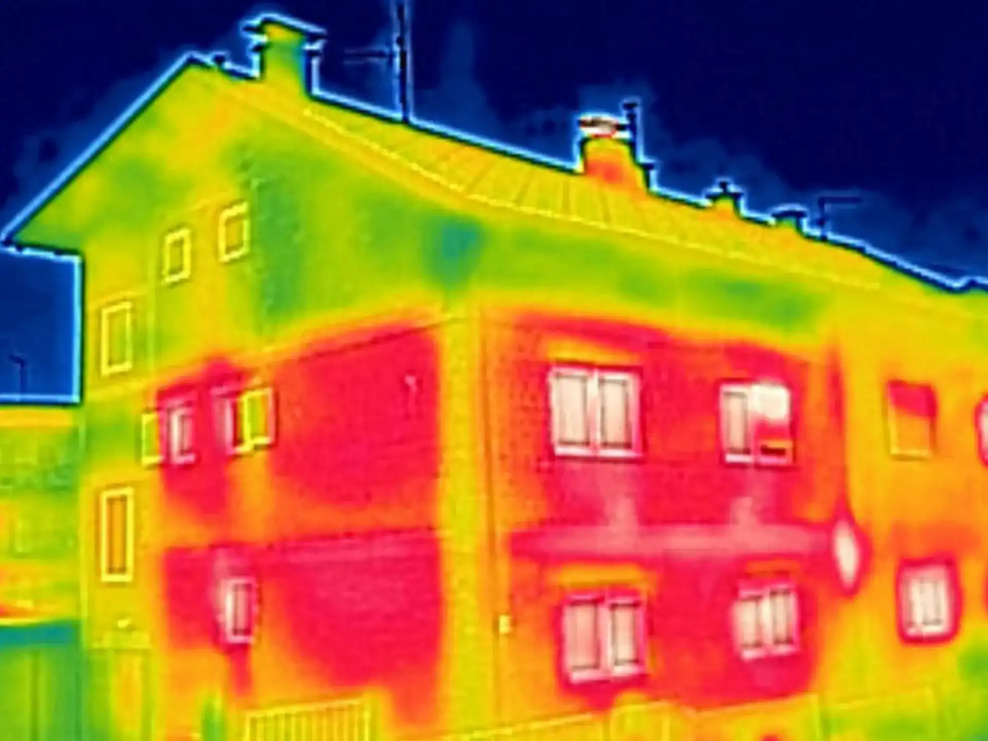
Using the most modern drone equipment we can provide images and video of your structures at incredible heights. All of our media is in super high resolution with images and video available up to 4K. We can then back these images with a report for you and your team to understand issues that require further invasive inspection.
Get a Free Quote for a Drone Survey or Inspection in Newcastle
Newcastle Upon Tyne (Newcastle) with a population of 302,000 is the largest city in the North East of England and the 8th most populous urban area in the UK.
Situated on the northern bank of the River Tyne, 8.5 miles from the North Sea, Newcastle is located 36 miles northwest of Middlesbrough and 15 miles north of Durham.
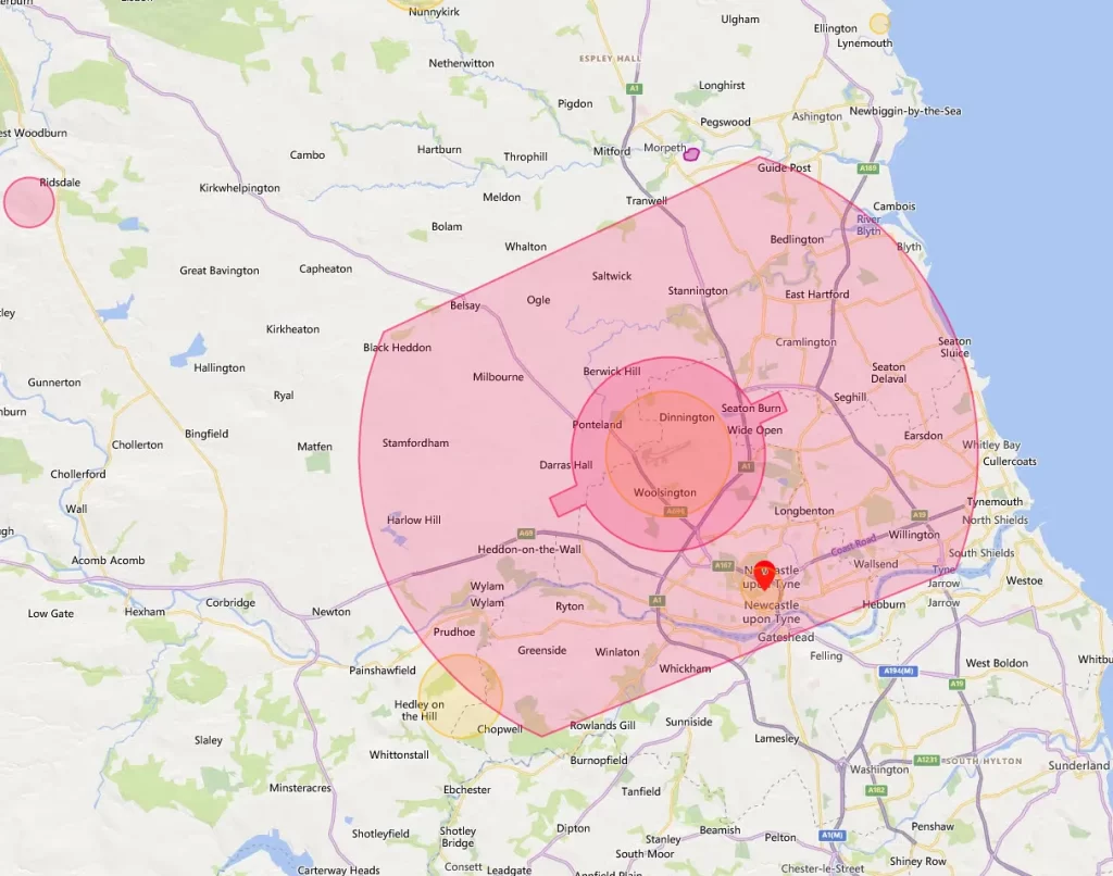
The city of Newcastle Upon Tyne is entirely located entirely within the Newcastle CTR (Controlled Traffic Region), meaning that drone flights within and around Newcastle will be carried out in Class D airspace and require clearance from Newcastle ATC prior to flight. The CTR extends NE to SW to Gateshead in the SE. Newcastle Hospital Helicopter Ambulance also operates within the city centre, around Royal Victoria Infirmary.
With Newcastle being such a large city, there will be numerous local considerations that should be factored into your drone flight planning along with the usual concerns when flying around towns and cities such as congestion, travel networks etc. It is also important that rail networks should always be factored into your planning as Network Rail has their own regulations regarding drones around its property in addition to CAA regulations.
While drone flights require greater planning and authorisation in and around town centres, this does not mean that we are unable to fly in these areas. Our trained pilots, alongside our experienced administrative team, will work together to gain the permissions to carry out work in the trickiest of locations!
Drone Inspections Newcastle
If you don’t require a report you may just wish to inspect your site in Newcastle. Our pilots can work with you or your surveyors to inspect the whole building or focus on the sections most important to you. With our technology, we have systems such as live streaming allowing viewing by wearing a virtual reality headset. Allowing you to attend the site and direct our pilots to inspect areas you wish. The remote streaming allows you and your team to watch the drone inspection take place. Having direct communication with the pilot you can again point us in the right direction or get a closer more detailed look at your assets.
With our drone inspections, we deliver all footage in high quality with resolutions up to 4K available. Inspecting your assets from the air using drones provides a cheaper, faster and more reliable way of inspection without the need for scaffolding, cherry pickers or other expensive equipment. Not only that, from site visits to the delivery of images, can be done within a 48-hour turnaround. Our drone inspections are delivered via a secure, password-secure URL for you to share with your team, suppliers or contractors that may be carrying out repairs.
Contact Drone Site Surveys today to book your drone inspection or survey anywhere across the Newcastle region. Our team will take a few details from you and provide a tailored quote.
Contact Us Today to Book Your Drone Survey or Inspection in Newcastle
Along with our surveys and inspection, we can provide in-depth mapping for your site. Using high-quality images, high-precision GPS and photogrammetry, we can map your site so that you don’t need to visit.
This highly detailed map can help solve clarity issues along with being able to see contour lines, and accurate borders (accurate to 1cm). These can then be overlaid onto images to allow you to build up the ultimate picture of your construction site. You can even combine our drone mapping with construction site progress and time lapse video to provide you with an ultimate overview of your construction progress from start to finish.
Surveyor Support Services
As well as providing detailed reports, drone mapping, inspections and surveys we are available to be an all-round surveyor support service. Our team understand your role as a surveyor and how to make your job on-site easier.
Come and speak to us about our surveyor support services as we don’t just offer drone inspections. We can provide internal and external scanning, 3D models and other services to help you measure, inspect and report on some of your assets without ever visiting a site. Let Drone Site Surveys take the labour away from yourself saving you time and money on your projects.
If your drone is over 250 grams and you’ll be flying outside, then by law you also need to register with the CAA. Rather than registering the drone, the CAA record the adult that will be responsible for the drone itself.
Anyone who is going to be flying the drone needs to look at the online education package on the same website and pass a short multiple-choice test to get their flyer ID. As well as being a legal requirement, the information will help set you up as a safe drone flyer and provide you with invaluable information to make you more confident with your drone.
You can always refer back to the safety information in the Dronecode, as this provides all the basic safety rules and advice that you need to comply with. The key to this is remaining below 400ft (120 Metres), keeping clear of aircraft and airfields, and not flying too close to people and property.
There is a fine of up to £1,000 for anyone found guilty of not complying with the drone registration requirements.
The CAA permission only addresses the flight safety aspects of the flight operation and does not constitute permission to disregard the legitimate interests of other statutory bodies such as Northumbria Police and the other Emergency services and the Highway Agency.