Drone Surveys and Inspection in Penrith
Here at Drone Site Surveys we cover drone surveys, inspection and mapping across Penrith and the whole Cumbria region. Contact us today to find out exactly how Drone Site Surveys can help you work smarter using our full suite of drones and surveyor support services.
Find out More Here
Drone Surveys & Inspection Penrith
Drone Surveys Penrith
Here at Drone Site Surveys, we enable the construction industry to work smarter by using unmanned aerial vehicles (UAVs/Drones) to inspect, measure and map areas without the need for time-consuming and expensive equipment hire. By having a drone survey across Penrith, you negate the need for scaffolding, cherry pickers or other ways of viewing your building or construction site at height.
As a CAA-approved drone company and a Construction Line Gold accredited business, we have undertaken 1000s of drone surveys across the Penrith and the wider Cumbria region.
Using the most modern drone equipment we can provide images and video of your structures at incredible heights. All of our media is in super high resolution with images and video available up to 4K. We can then back these images with a report for you and your team to understand issues that require further invasive inspection.
Get a Free Quote for a Drone Survey or Inspection in Penrith
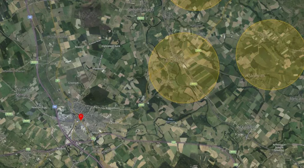
Penrith is a market town on the border of the Lake District National Park in the North of England. Located in the county of Cumbria, in the Eden Valley, Penrith has a population of 15000 lies just off junction 40 off the M6 motorway approximately 20 miles south of Carlisle and 55 miles north of Lancaster.
The Great North Air Ambulance base at Langwathby to the northeast is an area of increased risk and air operations from this base should be considered when flying drones around this airspace. Ultralight and Glider sites at Skelling Farm and Glassonby will also affect flight planning in the areas further North-East of Penrith itself.
Penrith is on the West Coast Main Line with trains running from London, Liverpool, and Manchester to Glasgow and Edinburgh. Network Rail requires specific permissions to operate drones around and near their property so this will need to be factored into your flight planning.
While drone flights require greater planning and authorisation in and around restricted zones, this does not mean that we are unable to fly in these areas. Our trained pilots, alongside our experienced administrative team, will work together to gain the permissions to carry out work in the trickiest of locations!
Drone Inspections Penrith
If you don’t require a report you may just wish to inspect your site in Penrith. Our pilots can work with you or your surveyors to inspect the whole building or focus on the sections most important to you. With our technology, we have systems such as live streaming allowing viewing by wearing a virtual reality headset. Allowing you to attend the site and direct our pilots to inspect areas you wish. The remote streaming allows you and your team to watch the drone inspection take place. Having direct communication with the pilot you can again point us in the right direction or get a closer more detailed look at your assets.
With our drone inspections, we deliver all footage in high quality with resolutions up to 4K available. Inspecting your assets from the air using drones provides a cheaper, faster and more reliable way of inspection without the need for scaffolding, cherry pickers or other expensive equipment. Not only that, from site visits to the delivery of images, can be done within a 48-hour turnaround. Our drone inspections are delivered via a secure, password-secure URL for you to share with your team, suppliers or contractors that may be carrying out repairs.
Contact Drone Site Surveys today to book your drone inspection or survey anywhere across the Penrith region. Our team will take a few details from you and provide a tailored quote.
Contact Us Today to Book Your Drone Survey or Inspection in Penrith
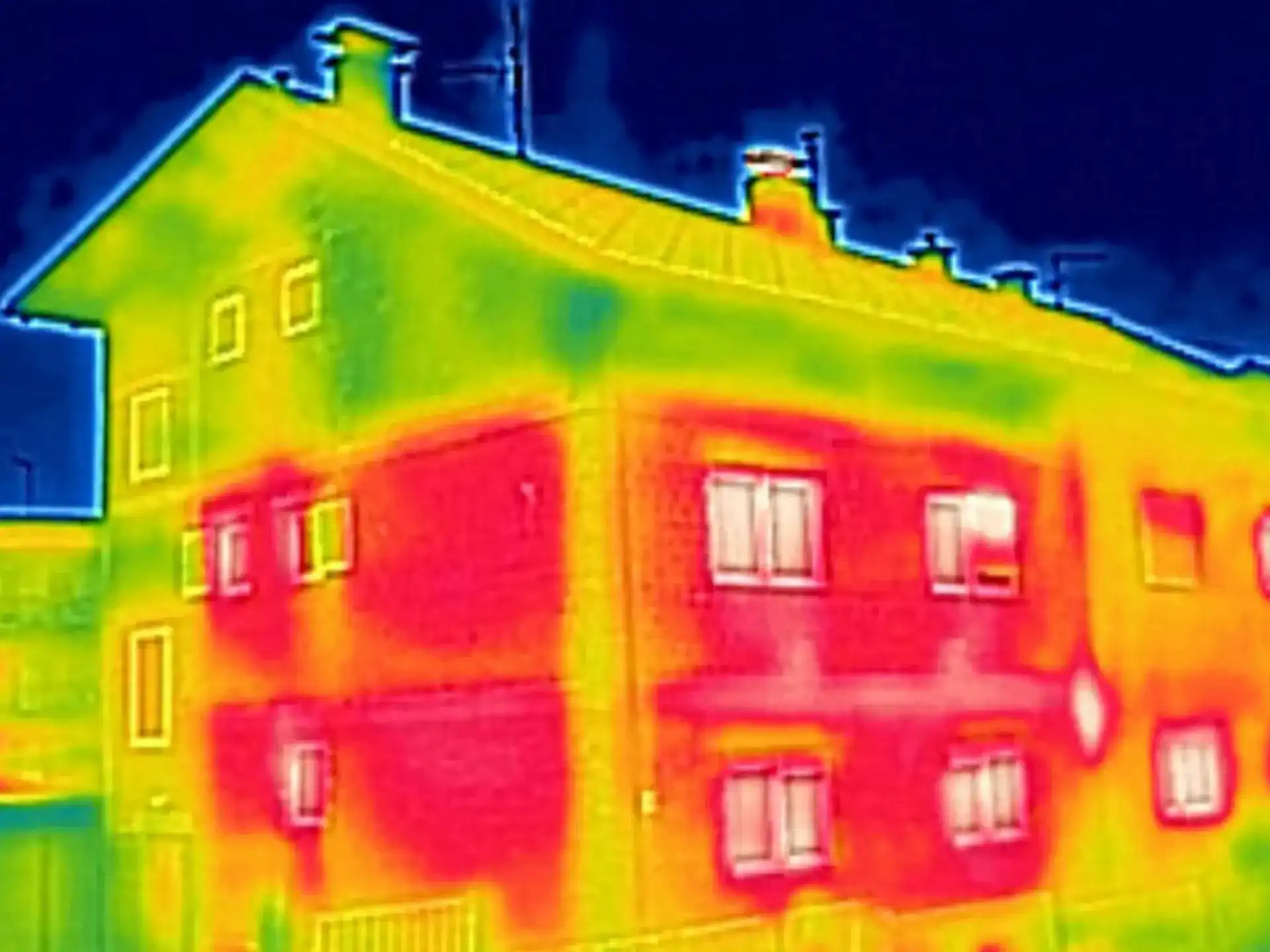
A common service we provide here at Drone Site Surveys is the inspection of roofs across Penrith to assess their condition. We can carry this out on both domestic and commercial roofs. Whether recent storm damage has occurred and you’d like to inspect, you’re carrying out regular maintenance checks, or you are considering installing solar panels, our experienced pilots can come and carry out an aerial survey of your roof. This can be useful for both pitched and flat roofs. As well as a visual inspection, we can supply a thermal survey to inspect for any areas of significant heat loss.
Drone Mapping Penrith
Along with our surveys and inspection, we can provide in-depth mapping for your site. Using high-quality images, high-precision GPS and photogrammetry, we can map your site so that you don’t need to visit.
This highly detailed map can help solve clarity issues along with being able to see contour lines, and accurate borders (accurate to 1cm). These can then be overlaid onto images to allow you to build up the ultimate picture of your construction site. You can even combine our drone mapping with construction site progress and time-lapse video to provide you with an ultimate overview of your construction progress from start to finish.
Surveyor Support Services
As well as providing detailed reports, drone mapping, inspections and surveys we are available to be an all-round surveyor support service. Our team understand your role as a surveyor and how to make your job on-site easier.
Come and speak to us about our surveyor support services as we don’t just offer drone inspections. We can provide internal and external scanning, 3D models and other services to help you measure, inspect and report on some of your assets without ever visiting a site. Let Drone Site Surveys take the labour away from yourself saving you time and money on your projects.
It is easy to fly and for a drone to hover over someone’s property. Case law has established that the rights of a property owner are restricted in relation to the airspace above his land to such a height as is necessary for the ordinary use and enjoyment of his land. This would be a matter of judgement in each case and whether or not there had been an invasion of privacy or an established nuisance would depend upon the frequency of flights, the height of those flights etc.
Based on existing case law, it may be argued that flying a drone above another’s property at heights so as not to interfere with that party’s ordinary use of the land is unlikely to constitute a trespass. In addition to this, photographing that person’s property on occasion is unlikely to constitute a nuisance. Matters do become more complex and less certain however when a drone is flying over another’s property on multiple occasions or even hovering in one place and taking multiple pictures.
The courts have not drawn a line as to what exactly will constitute trespass or nuisance by drones in these instances and therefore best practice is to ensure that the landowner’s permission is obtained.
Drone operators must have permission from the owner of the land where a drone takes off and lands.
Avoid disturbing wildlife, especially ground nesting birds on open fells. They can easily be disturbed and abandon their chicks from March to July, and disturbing wild bird nests is illegal. Flying drones is not permitted on nature reserves, SSSIs or on National Trust property.
Be respectful of other users, their privacy and their enjoyment of the peace of the national park.
Be respectful of local farmers and their work, particularly avoiding disturbing sheep at lambing time.