

As we are Drone Site Surveys, our bread and butter service is drone surveys. However, there appears to be some confusion as to what a survey may actually entail. So we are going to explain what is a drone survey and why is it different to a drone inspection. So what is a drone survey? Put it plainly, it’s a survey of your property using images and video taken from a drone. The images are processed and viewed on a computer and a report is compiled with recommendations and findings of issues your roof may have. It’s important to note, that a drone survey must have a document that details findings otherwise if there is no document all you have is a drone inspection.
Why is Using a Drone Better Than a Traditional Survey?
Using a drone provides a number of advantages. First off, it’s important to consider what you are surveying. If you are using a drone to survey a downstairs window for example, then you’re probably doing it wrong. However, surveying at height involves a number of problems that drones help solve.
- Risk: Working at height carries risk. If it’s on a scaffolding, cherry picker or a ladder, there is a risk to life. With a drone, this is not necessary as a pilot takes off and keeps their feel planted firmly on the ground.
- Cost: This comes hand in hand with risk. When there is a danger to life completing a job, the cost invariably goes up. Whether that’s in the cost of the manpower, or equipment hire, it’s more expensive to survey with traditional methods. Equipment hire also may come with the need for road closures or supervisory staff to ensure the equipment is being used safely. This adds to the cost. A drone company will send a pilot, this pilot may have 1 other person as a spotter however but that is it, we own the equipment needed so this will drive your surveying costs through the floor.
- Quality: A drone is a small and nimble piece of equipment and a roof or other assets at height are often complex. A drone can survey every angle of your asset in 4K ultra HD quality. Something you could never have done traditionally as accessing these complex assets increases the danger and is often impossible depending on the asset being surveyed.
- Speed: Any of the above, particularly equipment hire and road closures can severely slow down a traditional survey. However, a drone survey may mean a pilot on site for a few hours, then analysing the findings and producing a report. A survey can typically be turned around in 3 working days. In that time you may not have been able to even secure a scaffolding to get to the required height. This is why we use the tagline “Work Smarter” Drones help you and your surveyors work smarter saving time and money.
Will Drones Replace Surveyors?
We are asked this question all the time. However, will drones ever replace surveyors? No, the need for a qualified surveyor will never die. A drone will just change the way a surveyor does their job, but the need to analyse the footage and make recommendations requires a surveyor and that will never change.
If a surveyor no longer needs to attend a site, this will be a good thing and will free up surveyors time. So instead of replacing surveyors, instead drones make their life easier and speed up the delivery of their reports.
What Options Do Drone Surveys Give
There are a number of options for drone surveys. We’ve mentioned the report that can be produced however there are a few other items that a drone surveying company such as ourselves can provide.
- Advanced Survey from a RICS Surveyor: This is a special survey carried out by a RICS Accredited surveyor. Depending on the choice of survey you require, they can provide a desktop survey based on the provided footage. Or, they could physically visit the premises and perform a further in-depth analysis combined with our footage. This report can be used to help in insurance or warranty claims.
- Measurements & Models: Our drones, combined with ground control points, give us an accuracy of +- 2cm. We then process this using photogrammetry software. When processed, you see a 3D model of your site, where measurements can be taken. This is particularly good for construction site progress or measuring stock volumes as it’s much faster, cheaper and more accurate than traditional methods.
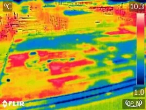
- Thermal Reports: Our team are qualified thermographers and our drones carry the latest in thermal cameras. With a thermal survey, our team can identify issues such as water ingress or heat loss. These are fantastic additions to your drone survey if you think there are particular sections of your assets that may have failed. See an example thermal image below.
Conclusion
In conclusion, a drone survey is a very useful and powerful tool. If you currently perform any surveys at height, its worth speaking with our team. We can talk you through all the options and see if there is a way that Drone Site Surveys can help reduce your costs and speed up your surveying techniques.