
Future-proofing homes starts with understanding where existing buildings are vulnerable to climate risk. For housing providers, sustainability teams and asset managers, clear evidence is essential before planning repairs, retrofit work or long-term resilience investment.
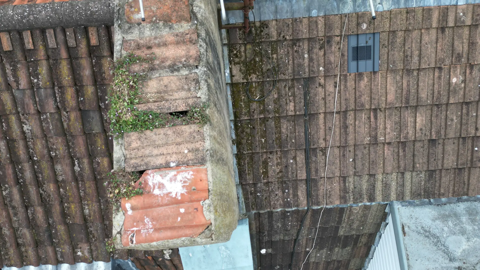
Drone survey data helps identify visible external issues such as ponding on flat roofs, blocked outlets, damaged coverings, weathered facades and drainage problems that may be missed from ground level.
By using safe aerial inspection, teams can build a clearer record of roof condition, rainwater systems, elevations and surrounding site features. This supports better decisions around maintenance, climate adaptation and asset resilience, while reducing the need for risky access methods.
Drone surveys do not replace every type of inspection, but they provide practical visual evidence that helps housing teams act earlier, prioritise budgets and protect homes against heavier rainfall, storms, heat and changing weather patterns.
Why Future-proofing Homes Starts With Better Building Evidence
Climate resilience planning depends on evidence. Before teams can prioritise investment, repairs or adaptation measures, they need to understand which homes are most exposed and which building details are likely to fail first.
Heavy rainfall, storms, overheating and changing weather patterns can place extra pressure on:
- Flat roofs and pitched roofs
- Gutters, outlets, downpipes and rainwater goods
- Facades, cladding, brickwork and render
- Chimneys, parapets, copings and roof edges
- Balconies, walkways and exposed junctions
- Hard surfaces, slopes and drainage paths around a property
- Trees, neighbouring structures and estate layouts
Ground-level inspections remain important, but they can miss high-level defects or the wider relationship between a building and its surrounding site. Aerial inspection gives teams a structured way to view roof layouts, external elevations, rainwater routes, nearby surfaces, tree cover and drainage patterns from a safer and more useful perspective.
This wider view supports better asset resilience planning because it shows not only the visible defect but also the context around it.
For example, a blocked outlet on a flat roof is not only a maintenance issue. It may also indicate a greater vulnerability during intense rainfall. Staining below a coping detail may not confirm a leak on its own, but it can help direct a follow-up inspection. Repeated imagery after storms can also show whether a repair has reduced the risk or whether a deeper issue remains.
What Is Climate-risk Drone Survey Data?
Drone survey data for assessing climate risk is visual and technical evidence captured by a drone to help evaluate how external building features and site conditions may respond to climate-related pressures such as heavy rain, storms, heat, surface water, and weathering.
For housing and property teams, this evidence can include:
- High-resolution roof imagery
- Rainwater goods and drainage observations
- Facade and elevation condition records
- Thermal imagery, where appropriate
- Site context photographs
- Progress and comparison records
- Point cloud or mapping data for more detailed asset understanding
- Practical reporting on areas requiring closer inspection
The aim is not simply to collect attractive aerial images. The aim is to produce useful information that supports real decisions about repairs, maintenance, risk prioritisation and long-term resilience.
Where Aerial Inspection Supports Future-proofing Planning
A good survey begins with the question the client needs to answer. The aim is not to collect attractive images. The aim is to gather evidence that helps people make practical decisions.
Once the question is clear, the survey can be planned around the useful outputs rather than the novelty of the drone. Drone Site Surveys works across roof inspections, building inspections, thermal surveys, pre-solar surveys, point cloud data, progress monitoring and housing disrepair investigations, so the method can be matched to the decision being made.
- Roofs and drainage: Look for ponding, blocked outlets, staining, damaged coverings and other signs that water is not being managed properly.
- Exposed elevations: Inspect weathered areas, failed details and places where water may be tracking into the building fabric.
- Site context: Capture trees, surfaces, slopes, drainage paths and neighbouring features that may influence risk.
- Repeat inspections: Compare conditions before and after storms, seasonal changes or planned works.
What Useful Drone Survey Outputs Should Be Included?
Drone survey work becomes valuable when it produces information that teams can review, compare and act on. A folder of unlabelled photographs rarely helps a busy asset, compliance or sustainability team.
For climate risk and housing resilience planning, useful drone survey outputs may include:
- A clear record of the condition of the roof and rainwater goods
- Aerial evidence for asset resilience planning
- High-level external condition imagery
- Site context imagery for drainage and estate decisions
- Before-and-after records following severe weather
- Comparison of imagery after the completed works
- Marked-up images showing key areas of concern
- A practical shortlist of areas needing closer inspection
- Clear notes on survey limitations and visibility
- Recommendations for follow-up inspection where required
The most useful reports are clear, practical and proportionate. They should help the client understand what was seen, why it matters and what may need to happen next.
How Teams Can Use Survey Data Responsibly
Drone surveys work best as part of a wider inspection and asset management process. They can reduce unsafe access, improve visibility and create a strong visual record, but they should not be treated as a single answer to every building problem.
Some issues require:
- Hands-on testing
- Internal inspection
- Moisture readings
- Structural assessment
- Specialist roofing assessment
- Intrusive investigation
- Laboratory analysis
- Resident evidence or repair history review
A responsible drone survey should make these limits clear. It should explain what was visible, what was not visible and where further checks may be needed.
This matters for trust. Housing providers need evidence that can stand up to scrutiny. Sustainability and resilience teams need records that support long-term planning rather than assumptions. Residents need confidence that decisions are based on clear evidence rather than guesswork.
Turning Visual Evidence Into Better Climate Adaptation Decisions
The biggest benefit of drone survey data is fewer blind spots.
A compliance lead can keep a clearer record of external conditions. A repairs manager can see defects that were difficult to inspect from ground level. An asset manager can judge whether a property needs urgent attention, planned maintenance or further specialist review.
For climate adaptation planning, this evidence can support better prioritisation by helping teams identify:
- Buildings with repeated drainage problems
- Roofs nearing the end of their useful life
- Exposed elevations affected by weathering
- Sites where surface water may create future issues
- Areas where vegetation or surrounding surfaces influence risk
- Repairs that need to be checked after severe weather
- Properties that may benefit from planned maintenance before defects escalate
This helps housing teams move from reactive decision-making to a more planned, evidence-led approach.
Future-proofing Homes Starts With Understanding Vulnerability Early
Future-proofing homes against climate risk means understanding vulnerability before problems become more costly, disruptive or difficult to manage.
Drone survey data gives housing teams a safer and clearer way to inspect external conditions, record changes over time, and prioritise the areas that need attention. It supports better maintenance decisions, stronger climate adaptation planning and a more reliable evidence base for asset resilience.
With clear aerial evidence, housing teams can act sooner, target budgets more effectively and build a stronger record for long-term climate risk decisions.
Speak to Drone Site Surveys
If you manage housing stock, estates or property assets and need clearer evidence for climate resilience planning, Drone Site Surveys can help you capture practical, decision-ready survey data.
Contact Drone Site Surveys to discuss roof inspections, external building surveys, drainage evidence, thermal surveys, pre-solar surveys or repeat inspection programmes.