
Housing asset resilience drone surveys help housing providers understand visible risks across roofs, gutters, outlets, elevations, drainage routes and estate areas before extreme weather turns small defects into larger repairs.
For asset managers, risk teams and planned maintenance leads, drone surveys provide clearer visual evidence of hard-to-access areas. This can support safer inspections, better contractor briefs, planned maintenance decisions, budget planning and before-and-after condition records.
Drone surveys do not replace every type of building survey. Some issues still need physical access, moisture testing, intrusive inspection or specialist review. Their value is in helping housing teams see external conditions earlier, prioritise work more confidently and reduce unnecessary first-stage access to roofs or high-level elevations.
What Housing Asset Resilience Means in Practice
Housing asset resilience means understanding how prepared homes are for pressure from storms, heavy rain, wind, heat, frost and long-term weathering. It is not only about reacting after bad weather. It is about knowing where stock may already be vulnerable.
UK Government housing data also highlights the importance of climate-resilient homes, with housing described as being on the front line of adaptation challenges linked to climate change and extreme weather.
A flat roof with ponding water may be at greater risk during prolonged rainfall. A blocked outlet can increase the chance of damp or water ingress. Failed details on exposed elevations may allow water to track into the building fabric. Poor drainage routes or hardstanding can also affect how water moves around a property or estate.
Good resilience planning starts with visibility. When condition records are unclear, maintenance decisions can become slower, more reactive and more expensive. Clear visual evidence helps housing providers make better decisions before problems escalate.
Where Drone Surveys Can Support Weather-Ready Stock
Drone surveys are particularly useful where external condition evidence is difficult, unsafe or inefficient to collect from ground level.
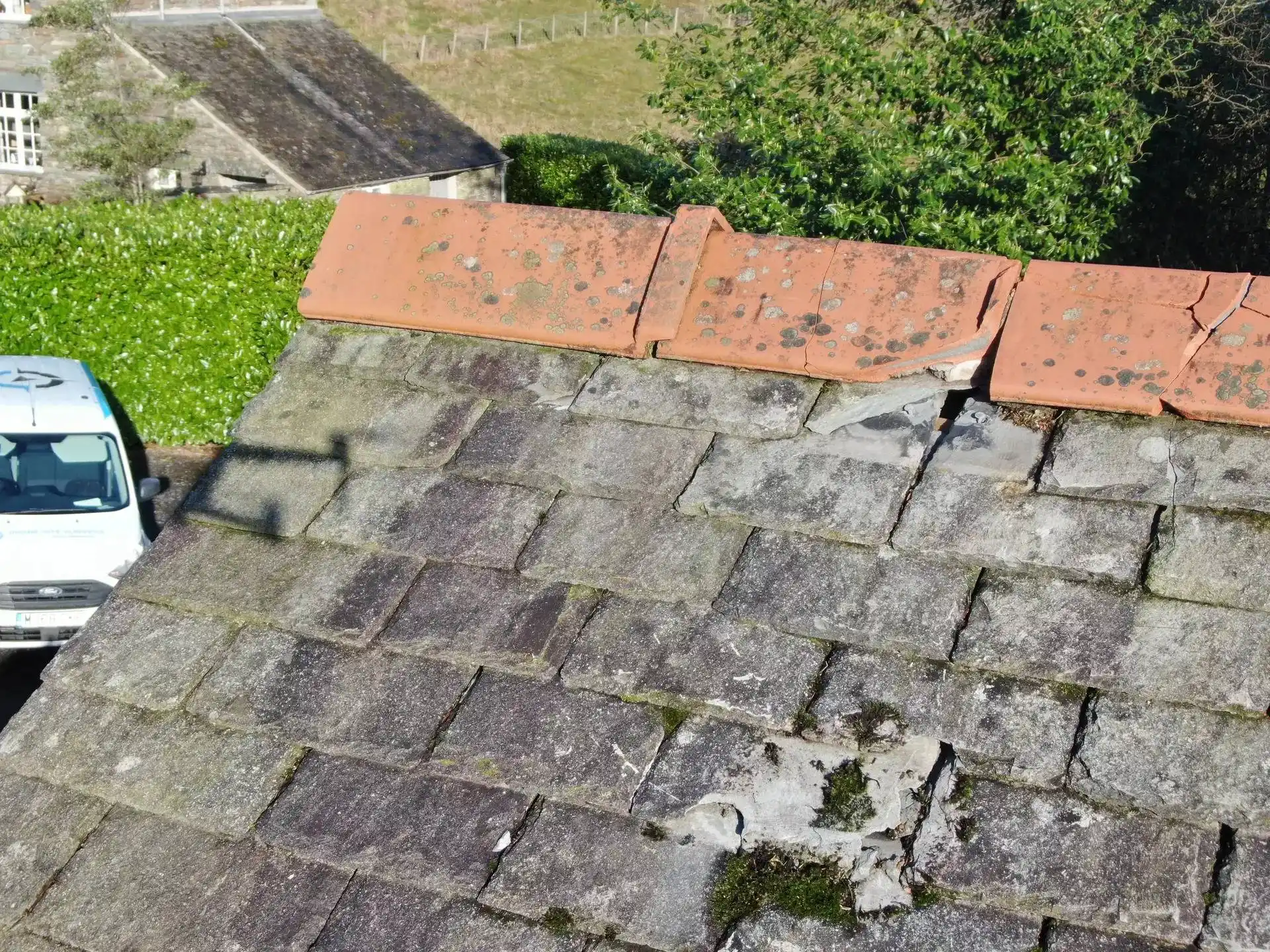
- Roofs and drainage: Look for ponding, blocked outlets, staining, damaged coverings and other signs that water is not being managed properly.
- Exposed elevations: Inspect weathered areas, failed details and places where water may be tracking into the building fabric.
- Site context: Capture trees, surfaces, slopes, drainage paths and neighbouring features that may influence risk.
- Repeat inspections: Compare conditions before and after storms, seasonal changes or planned works.
What Should a Housing Drone Survey Include?
A useful drone survey should provide structured evidence, not just aerial photographs. Depending on the brief, outputs may include the following:
- Aerial imagery of roofs, elevations, gutters and estate areas
- Visible condition records for asset management files
- Marked-up images showing areas of concern
- Before-and-after records following severe weather
- Site context imagery for drainage and access decisions
- A practical list of areas needing closer investigation
- Evidence to support contractor scopes and planned works
The reporting process matters. The drone is only the tool. The real value comes from the brief, the inspection plan, the quality of evidence and the next decision the survey helps the client make.
How Do Drone Surveys Reduce Risk?
Working at height can introduce significant risk, especially when roofs are fragile, difficult to access or poorly understood. A drone survey can often reduce the need for immediate physical access during the first stage of external assessment.
This does not remove the need for competent inspection. A survey may still recommend hands-on checks, moisture testing, intrusive investigation, repair access or specialist review. However, it can help teams target the next step more safely and efficiently.
Instead of sending contractors onto a roof with limited information, housing providers can use aerial evidence to decide where access is needed, what equipment may be required and which areas should be prioritised.
When Should Housing Asset Consider a Drone Survey?
A housing provider may benefit from a drone survey when it needs clearer evidence of external conditions, particularly across hard-to-access areas.
Common triggers include:
- Preparing stock for winter or severe weather
- Reviewing flat roofs, gutters and drainage after heavy rainfall
- Investigating recurring damp, leaks or resident complaints
- Planning cyclical maintenance or capital works
- Checking completed repairs from a safe distance
- Building evidence before budget or contractor decisions
- Inspecting blocks, estates or roof areas at scale
- Recording the condition before and after a storm event
Drone surveys are most effective when the brief is clear. The survey should be planned around the decisions the client needs to make, not simply around collecting aerial images.
What Are the Limits of a Drone Survey?
A drone survey can show visible external conditions, but it cannot confirm every hidden defect. It may not identify concealed moisture paths, structural movement, insulation failure, internal damp causes or defects hidden beneath coverings.
Weather, permissions, privacy, airspace restrictions and site conditions can also affect whether drone inspection is suitable.
For this reason, drone surveys should form part of a wider asset management process, alongside competent surveyors, contractors, maintenance records, resident reports and specialist testing where needed.
How Drone Site Surveys Support Housing Asset Resilience
Drone site surveys help housing providers gather practical aerial evidence for roofs, elevations, drainage routes and external asset areas. Our surveys are designed to support clearer decision-making, not just provide images.
A well-planned drone survey can help your team understand what is visible, what needs attention and what may require closer investigation. This can support planned maintenance, risk reviews, contractor scopes, repair prioritisation and long-term comparison records.
Final Thoughts
Preparing housing stock for extreme weather starts with knowing where weaknesses may exist. Roofs, gutters, outlets, drainage paths and exposed elevations all need regular attention, especially when budgets are under pressure.
Housing asset resilience drone surveys can help providers inspect difficult areas more safely, gather clearer evidence and make better-informed maintenance decisions.
They work best as part of a wider asset management strategy. The drone captures the evidence. The value is in how that evidence supports the next decision.


