
Green infrastructure is not just about planting, biodiversity, or attractive outdoor spaces. On housing estates, commercial sites and public buildings, it also plays a practical role in asset resilience.
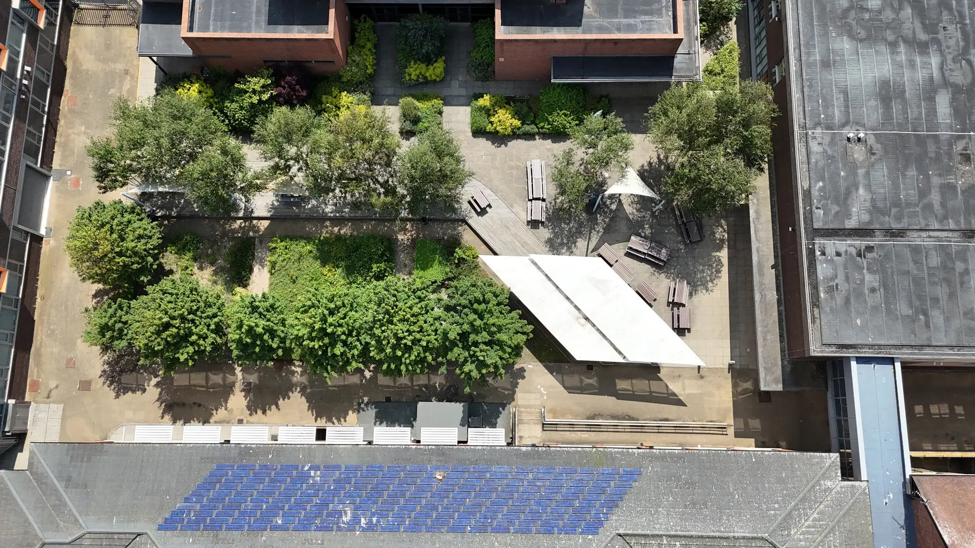
Trees, planted areas, drainage routes, roofs, gutters, gullies, hardstanding and water pathways all affect how buildings respond to heavy rain, storms and prolonged heat.
When these features work together, they can help manage surface water, reduce overheating and support healthier places.
Poor maintenance or misunderstanding of these features can heighten the risk of leaks, dampness, blocked drainage, fabric deterioration, and expensive reactive repairs.
This is where drone surveys can support planning for the resilience of green infrastructure assets. Used correctly, they provide visual evidence of how built assets and natural features interact across a site.
What Is Green Infrastructure Asset Resilience Planning?
Green infrastructure asset resilience planning is the process of understanding how natural and built features affect the long-term performance of buildings and estates.
It looks at questions such as the following:
- Where does surface water travel during heavy rain?
- Are roofs, gutters and outlets managing water effectively?
- Are trees, vegetation or shading affecting building fabrics?
- Are drainage routes blocked, hidden or under pressure?
- Are hard-standing areas directing water toward vulnerable elevations?
- Which assets may need closer inspection before failure occurs?
For housing providers, local authorities, estate managers, sustainability teams and facilities managers, this evidence can support better maintenance planning, safer access decisions and more informed investment.
Why Drone Surveys Are Useful for Asset Resilience
A drone survey gives teams a clearer view of areas that are difficult, unsafe or time-consuming to inspect from the ground. This can include roofs, high gutters, flat roof outlets, parapets, upper elevations, drainage features and the wider site context around a building.
The value is not simply in taking aerial photographs. The value is in collecting usable evidence that helps answer a specific asset management question.
For example, a drone inspection may show early roof ponding, staining around an outlet, vegetation close to a vulnerable elevation, surface water routes across hardstanding, or blocked rainwater goods that are not visible from ground level.
This information can help teams decide whether an area needs monitoring, maintenance, contractor pricing, intrusive inspection or further specialist assessment.
Common Green Infrastructure and Building Risks Drones Can Help Identify
Drone surveys can support resilience planning by recording visible conditions across both the building and the surrounding estate.
Roofs and Rainwater Goods: Flat roofs, pitched roofs, valleys, gutters, downpipes and outlets are central to water management. Drone imagery can help identify ponding, staining, vegetation growth, blocked outlets, damaged coverings, slipped materials and areas where water may not be draining correctly.
Drainage Routes and Surface Water Movement: Hardstanding, paths, car parks, gullies and slopes can affect how water moves across a site. Aerial views help show whether water appears to be directed away from buildings or towards vulnerable elevations, entrances, basement areas or low points.
Trees, Vegetation and Shading: Trees and planted areas can support biodiversity, shading and cooling. However, they can also hide roof edges, block drainage routes, contribute to leaf build-up or affect access for maintenance. Drone surveys can help record the relationship between vegetation and building fabric.
Exposed Elevations: Upper walls, cladding, chimneys, parapets and exposed elevations can show signs of weathering, staining or moisture tracking. Aerial inspection helps provide a safer first view before deciding whether closer hands-on access is required.
Post-Storm and Seasonal Comparisons: Repeat drone surveys can create a useful visual record before and after storms, heavy rainfall, planned works or seasonal vegetation changes. This supports better record keeping and makes changes easier to compare over time.
What Good Drone Survey Outputs Should Include
A drone survey should produce more than a folder of images. For asset resilience planning, outputs need to be easy to review, share and act on.
Useful outputs may include:
- Clear aerial imagery of roofs, elevations and site context
- Marked-up defect locations or areas of concern
- Roof and rainwater goods condition records
- Visual evidence of drainage routes and surface water risks
- Before and after records for storm damage or maintenance works
- A practical shortlist of areas needing closer investigation
- Secure online access to imagery, reports and supporting files
The output’s accuracy hinges on the question posed. A maintenance team may need detailed roof imagery. A sustainability lead may need wider evidence of shading, drainage, vegetation and heat-related risks. A planner may need to understand how buildings and green infrastructure connect across an estate.
Can Thermal Drone Surveys Help?
Thermal drone surveys can be useful in some circumstances, especially when teams are investigating potential heat losses, insulation gaps, or building performance issues.
However, thermal data needs careful planning. Weather, time of day, building use, surface conditions and temperature differences can all affect the quality of the results. Thermal imagery should be treated as evidence to support further assessment, not as a standalone diagnosis.
A responsible survey should explain what the thermal data can show, what it cannot confirm, and whether additional inspection is needed.
How Drone Evidence Supports Better Decisions
Asset resilience depends on understanding three things: exposure, conditions, and consequences.
A small defect in a low-risk area may only need monitoring. The same defect above a vulnerable room, next to repeated water staining or near poor drainage, may need faster attention.
Drone evidence helps teams make these distinctions. It provides a visual record of what was visible at the time of inspection and helps connect roofing, drainage, vegetation, and site risks into one clearer picture.
Such evidence can support the following:
- Planned maintenance programmes
- Housing disrepair investigations
- Contractor briefing and pricing
- Sustainability and climate resilience reviews
- Roof replacement or repair planning
- Safer access decisions
- Estate-wide condition monitoring
It does not remove the need for hands-on testing, intrusive investigation or specialist follow-up where required. Instead, it helps make those next steps better targeted.
Questions to Ask Before Commissioning a Drone Survey
Before arranging a drone survey for green infrastructure or asset resilience planning, it is worth defining the purpose clearly.
Useful questions include:
- What decision does the survey need to support?
- Is the priority roof condition, drainage, heat loss, vegetation, storm damage or wider site risk?
- Does the site need a one-off inspection or repeat monitoring?
- Who will use the outputs?
- Is a marked-up report, image portal, thermal data or wider site overview required?
- Are there access, safety or operational restrictions to consider?
Clear questions lead to clearer outputs. They also reduce the risk of collecting unnecessary imagery that does not help the asset team make a decision.
The Key Takeaway
Drone surveys can play a useful role in green infrastructure asset resilience planning because they help teams see how buildings, drainage, vegetation and surface conditions interact.
The drone itself is only the tool. The real value comes from safe data capture, clear reporting, and practical evidence that helps estate teams, housing providers, sustainability leads, and contractors understand risk earlier.
Used well, aerial inspection can reduce blind spots, improve maintenance planning and support better long-term decisions about roofs, drainage, building fabric and green infrastructure.
For organisations managing complex estates, providers such as Drone Site Surveys can support this evidence-led approach by helping turn external building and site observations into usable inspection records.