
UK mobile network operators face a demanding infrastructure programme. The expansion of 5G Standalone, rising data use, completed 3G switch-offs and ongoing equipment upgrades are placing greater pressure on mast portfolios. Ofcom reported in May 2026 that outdoor 5G Standalone coverage ranged from 49% to 85% across the three operators that had deployed it, showing the scale of work still under way.
Every upgrade depends on reliable information about antenna positions, mounting arrangements, available space and asset condition. Yet records can quickly become outdated as equipment changes.
Manual climbing remains necessary for physical testing and hands-on work. Using it as the first step for every condition check or upgrade assessment, however, is often slow, costly and restrictive. Drone surveys provide a safer and more efficient way to gather the evidence needed for maintenance planning.
The Traditional Telecom Mast Survey Bottleneck
A conventional telecom mast survey may require trained climbers, specialist access equipment, rescue arrangements, exclusion zones and coordination with site owners. Scaffolding or mobile elevated work platforms may also be needed where access is restricted.
These arrangements increase costs before an engineer has collected the information needed to make a decision. They also lengthen mobilisation times and make multi-site inspection programmes harder to manage.
Working at height is a major health and safety consideration. Even with competent personnel and robust controls, climbing introduces risks that remote inspection can often avoid during the initial assessment. Weather, roadside locations and remote rural sites add further complications.
The result can be repeat visits, incomplete scopes and delays when planning repairs, equipment replacements or network capacity upgrades.
Drone Cell Tower Inspections UK: How the Process Changes
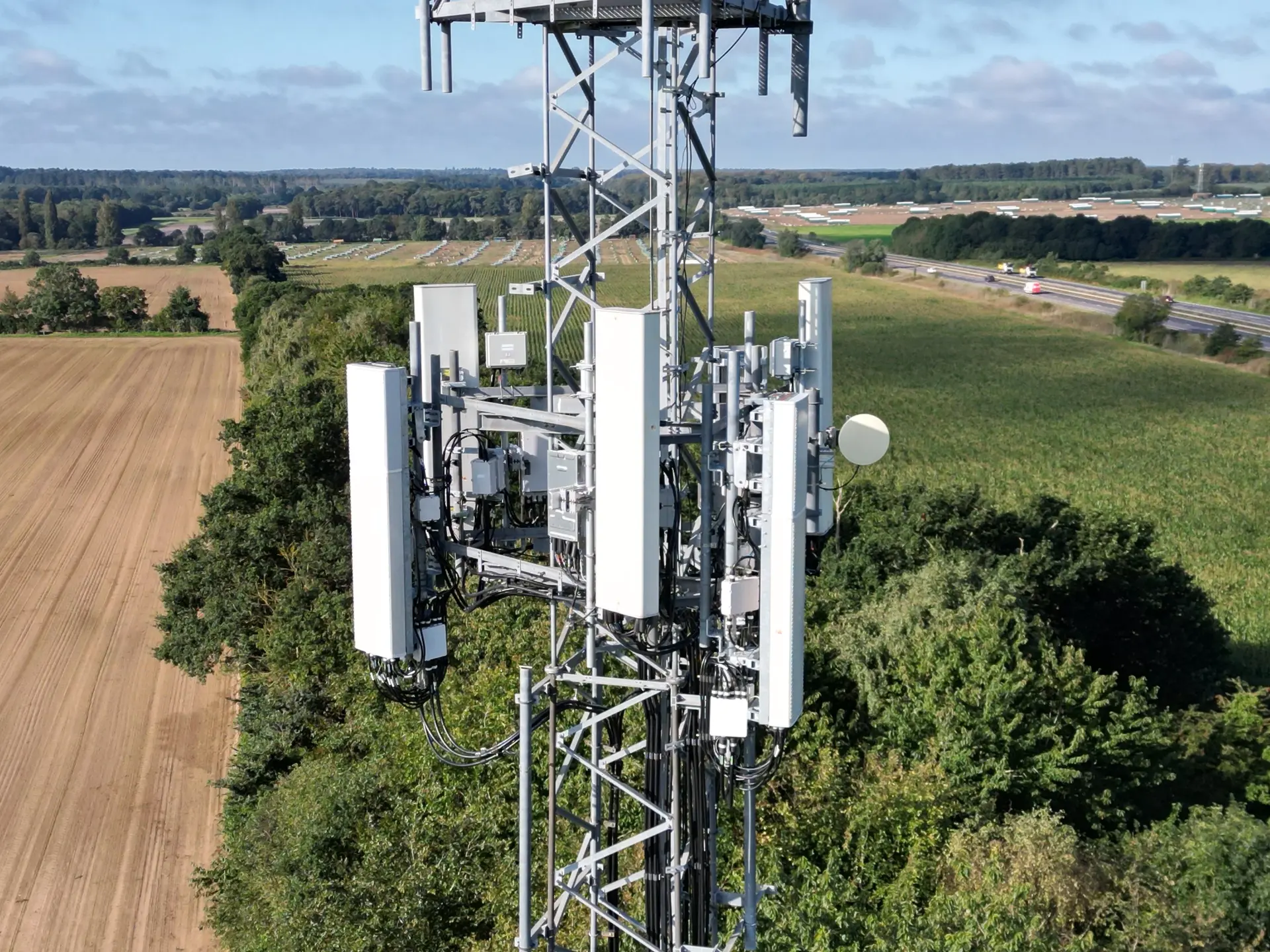
A drone can capture a cell tower from multiple elevations and angles without placing an operative on the structure. Following a planned capture sequence, the pilot gathers detailed imagery of antennas, mounts, feeders, brackets, bolts, platforms, ladders, cable management and the wider compound.
This creates a more complete visual record than a small set of ground-level photographs. It also reveals rear mounting arrangements, high-level connections and complex cable routes that are difficult to inspect from below.
Depending on the brief, Drone Site Surveys can provide high-resolution imagery, 4K video, photogrammetric 3D models, digital twins, georeferenced outputs and specialist analysis. Clients can use the captured data to assess height, azimuth, downtilt and plumb.
For a structural tower inspection, detailed imagery can help engineers identify visible corrosion, coating failure, damaged cable supports, missing components or distortion.
A drone does not replace intrusive testing or professional engineering judgement. Instead, it provides clearer evidence so teams can target physical access, testing and remedial work where they are genuinely required.
Faster Multi-Site Inspection Programmes
Drone Site Surveys can deliver coordinated multi-site programmes, helping clients gather consistent information across several towers without arranging a separate climbing exercise for every location.
Outputs can be provided through password-protected, non-indexed portals, with bespoke branded delivery options available for larger portfolios and ongoing inspection programmes.
Consistent capture also makes it easier to compare condition, equipment inventory and upgrade readiness across multiple assets.
Beyond Raw Data: The Delivery Portal Viewer
Flying the drone is only the capture stage. The real transformation comes from making the information easy to inspect, measure, share and revisit.
Sending hundreds of photographs in folders places the burden back on the client. Engineers must identify where each image was taken, compare views manually and search through files whenever a question arises.
Drone Site Surveys instead provides a secure online delivery portal that brings project outputs together in one accessible environment. Authorised users can review the asset remotely without installing specialised software.
Our proprietary, custom-built viewer supports detailed imagery, coordinate extraction and tools for measuring distances, areas and angles.
View High-Resolution Cell Tower Images
The portal gives clients access to crystal-clear images of the cell tower and its installed equipment. Users can zoom into connection points, mounting hardware, antenna faces, cable routes and visible defects without returning to site.
Teams can use the imagery to:
- Check equipment inventory against existing records
- Review corrosion or visible component damage
- Confirm cable routing and mounting configurations
- Share clear evidence with engineers and contractors
- Retain a dated visual record before maintenance work
Because the imagery remains available online, it can support later discussions, quotations, engineering reviews and maintenance decisions.
This is particularly useful when several stakeholders need to review the same asset. Instead of sending large files between teams, authorised users can access a consistent source of visual evidence through the secure portal.
Interact With an Accurate Photogrammetric 3D Model
Where the project includes photogrammetry, the delivery portal can host a detailed 3D model of the complete asset.
Users can rotate the model, change their viewing angle and understand how individual components relate to each other. This provides far greater context than viewing isolated photographs.
The model creates a practical foundation for 3D asset management and telecom asset digitisation. It becomes a shared reference for:
- Upgrade planning
- Design reviews
- Equipment inventory checks
- Contractor briefings
- Maintenance discussions
- Future comparison surveys
The 3D model also creates a digital snapshot of the tower at the time of inspection. Future surveys can then help teams assess visible changes, monitor asset condition and maintain a more dependable record of the structure.
Take Engineering Measurements Within the Viewer
The measurement tools are one of the delivery portal’s strongest commercial benefits.
Subject to the agreed survey specification and accuracy requirements, authorised users can take measurements directly from the 3D model instead of arranging another site visit simply to check a dimension.
Typical uses include:
- Checking antenna and equipment heights
- Reviewing azimuth, downtilt, plumb and relevant angles
- Estimating clearances between components
- Calculating available mounting space for new equipment
- Measuring distances across the structure or compound
This can support preliminary upgrade planning, equipment replacement decisions and feasibility discussions before physical work begins.
Where greater positional accuracy is required, the survey methodology can include suitable georeferencing and ground control. The required accuracy, coordinate system and intended use should be agreed before the survey so the resulting model supports the client’s engineering workflow.
Better 3D Asset Management and Maintenance Decisions
Telecom asset digitisation creates a more useful record than separate folders, reports and spreadsheets. A structured delivery portal can bring images, models, measurements and supporting documents together in one place.
This helps asset managers, radio planners, structural engineers and maintenance contractors collaborate more effectively.
It can reduce unnecessary site attendance, improve the quality of tender information and help teams define a clearer scope before anyone climbs the structure. Engineers can review the same evidence, discuss specific components and plan the next stage using a consistent visual reference.
Repeat drone site surveys can also build a reliable record of condition over time. This supports portfolio planning and helps infrastructure managers direct maintenance budgets towards the assets requiring attention first.
Why Choose Drone Site Surveys?
Drone Site Surveys carries out cell tower inspections, phone mast and radio tower inspections across the UK. We inspect monopoles, lattice towers, poles, rooftop installations, stub masts and other telecoms assets.
Our service combines planned aerial capture, detailed processing and secure digital delivery. We do not treat a telecom mast survey as a basic photography exercise. We focus on producing structured, accessible information that engineers and infrastructure teams can use.
Clients can commission a single telecom mast survey or a coordinated multi-site programme, with available outputs including:
- High-resolution imagery
- 4K video
- Photogrammetric 3D modelling
- Digital twins
- Georeferenced data
- Specialist analysis
- Secure online delivery
This combination of experienced drone operations, detailed data processing and practical digital delivery positions Drone Site Surveys as a leading UK provider of drone cell tower inspections.
Most importantly, our delivery portal turns captured data into useful asset intelligence. It gives teams a clear view of each structure, practical measurement tools and a secure environment for sharing evidence with authorised stakeholders.
Book a Live Demonstration of the Delivery Portal
Drone cell tower inspections reduce exposure to work at height, shorten the initial survey process and provide a richer record for telecoms maintenance.
Combined with a measurable 3D model and an accessible delivery portal, they support better planning, more focused engineer visits and stronger long-term asset records.
Infrastructure managers, engineers, tower companies and mobile network operators can contact Drone Site Surveys to discuss an individual mast inspection or a nationwide survey programme.
Book a live demonstration of our delivery portal viewer and see how your team can inspect high-resolution imagery, explore a complete 3D model and take practical measurements from one secure online platform.